


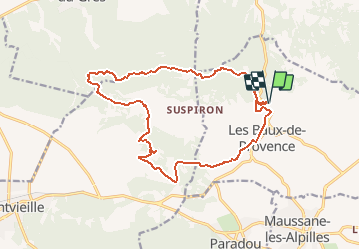
depart les baux vers le mont paon

gerardmicheline
User

Length
17.8 km

Max alt
264 m

Uphill gradient
465 m
Km-Effort
24 km

Min alt
74 m

Downhill gradient
470 m
Boucle
Yes
Creation date :
2020-01-27 16:44:42.981
Updated on :
2020-01-27 16:45:35.105
5h06
Difficulty : Very difficult

FREE GPS app for hiking
 SityTrail
IGN / Geographical institutes
SityTrail Plus
The world is yours!
About
Trail Walking of 17.8 km to be discovered at Provence-Alpes-Côte d'Azur, Bouches-du-Rhône, Les Baux-de-Provence. This trail is proposed by gerardmicheline.
Positioning
Country:
France
Region :
Provence-Alpes-Côte d'Azur
Department/Province :
Bouches-du-Rhône
Municipality :
Les Baux-de-Provence
Location:
Unknown
Start:(Dec)
Start:(UTM)
644585 ; 4845932 (31T) N.
Comments